SNB Geographic Data & Maps - Information
| PRODUCTS & SERVICES | SUPPORT | LINKS |
|
|
||||||||||
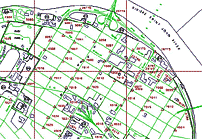
Digital Topographic Data Base � 1998 (DTDB) - Information The Digital Topographic Data Base - 1998 (DTDB98) is a digital representation of natural and cultural features of New Brunswick, organized into 1894 map windows (or files). It is made up of two databases: the Digital Terrain Model (DTM) Data Base and the Enhanced Topographic Base (ETB). The ETB, containing graphic files and attribute files, is used to create a planimetric map; however, the DTM data has no attribute files, and is a digital representation of elevations though the Province. Each of the 1894 files in the DTDB represents a 1:10,000 window encompassing 0.1 degree in longitude (7.5 kilometres) by 0.05 degree in latitude (5.5 kilometres).
What is included with the ETB? The ETB files are organized in 1:10,000 map windows and consists of:
ETB files contain topographic features organized into nine general categories: Buildings, Designated Areas, Delimiters, Land Cover, Land Features, Transportation (Road/Railroad), Structures, Utilities and Hydrography. Transportation and Hydrography are each maintained in their own files. The remaining seven general categories are maintained in one file. What is included with the DTM?
The DTM Data Base is a digital representation of elevations organized into individual DTM files with the same 1:10,000 windows used for the ETB. There are no attribute files associated with these files. The DTM files contain elevation mass points, check points, and spot heights. Spatial Framework
File Naming Convention The naming convention for the DTDB files is based on the latitude and longitude (expressed in decimal degrees) of the Southeast corner of the 1:10,000 windows. These file names are coded as follows: aaaabbbb, where
For example, the DTDB file name for the window having its Southeast corner at latitude 46� 00� 00�� N (or 46.00) and longitude 66� 54� 00 E (or 66.90) is 46006690. Available for Download� Here are the downloadable DTDB file packages:
The downloadable DXF file package contains three DXF files: The downloadable CARIS GIS file package contains three CARIS ASCII files plus three attribute files: The dowloadable ESRI Shapefile package contains three groups of files: For each file package, there are drawing and attribute support files available in the Support section. We highly recommend that you download these support files, they will help with the correct display of the information. The downloadable CARIS GIS file package contains one graphic CARIS ASCII files: The downloadable XYZ file package contains one text file: Please note: For more information on the Digital Topographic Data Base (DTDB), please use the Communication section on the Geographic Data & Maps � Main Page.
|
||||||||||
| © 2018 Service New Brunswick |  |
 |