|
|
Reference Indexes and Maps - Information
The Reference Indexes and Maps are part of the New Brunswick Administrative Areas Data Base. They include the Digital Topographic Data Base 1:10,000 and 1:20,000 map grids, as well as the National Topographic Series 1:50,000 and 1:250,000 map grids. Other reference indexes and maps are also available.
Each theme is a graphical representation of administrative features that approximate their size, configuration and location. The reference indexes and maps were not created from boundary surveys and have no official status. It is not intended that they be used for legal descriptions or to calculate exact dimensions or areas.
SPATIAL FRAMEWORK
Reference System: North American Datum 1983 (CSRS)
Projection: Stereographic Double
False Northing: 7,500,000
False Easting - 2,500,000
Resolution: X=0.05 metre, Y=0.05 metre, Z=0.1 metre
 |
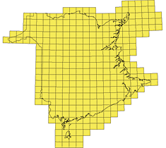
1:10,000 Grid (Theme 5006) |
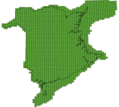
Provincial limits are not
included in this theme |
| |
This theme consists of the 2472 1:10,000 windows of the NB Digital Topographic Data Base 1998 (DTDB98). It was generated from data provided by Service New Brunswick.
The 1:10,000 Grid theme is a graphical representation of administrative features that approximate their size, configuration and location. This theme was not created from boundary surveys and has no official status. It is not intended that it be used for legal descriptions or to calculate exact dimensions or areas.
Available in AutoDesk DXF, CARIS ASCII and ESRI Shapefile formats. |
Main Products and Services - Reference Indexes and Maps - Top
|
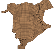
1:20,000 Grid (Theme 5028) |
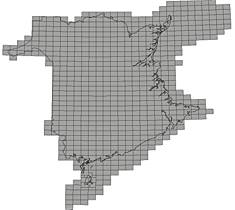
Provincial limits are not
included in this theme |
| |
This theme consists of the 508 1:20,000 windows of the New Brunswick Digital Topographic Data Base 1998 (DTDB98). It was generated from data provided by Service New Brunswick.
The 1:20,000 Grid theme is a graphical representation of administrative features that approximate their size, configuration and location. This theme was not created from boundary surveys and has no official status. It is not intended that it be used for legal descriptions or to calculate exact dimensions or areas.
Available in AutoDesk DXF, CARIS ASCII and ESRI Shapefile formats. |
Main Products and Services - Reference Indexes and Maps - Top
|
1:50,000 Grid (Theme 5005) |
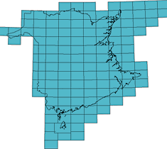
Provincial limits are not
included in this theme |
| |
This theme consists of the 125 1:50,000 windows of the New Brunswick National Topographic Series (NTS). It was generated from data provided by Service New Brunswick.
The 1:50,000 Grid theme is a graphical representation of administrative features that approximate their size, configuration and location. This theme was not created from boundary surveys and has no official status. It is not intended that it be used for legal descriptions or to calculate exact dimensions or areas.
Available in AutoDesk DXF, CARIS ASCII and ESRI Shapefile formats. |
Main Products and Services - Reference Indexes and Maps - Top
|
1:250,000 Grid (Theme 5004) |
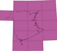
Provincial limits are not
included in this theme |
| |
This theme consists of 15 1:250,000 windows National Topographic Series (NTS) of New Brunswick. It was generated from data provided by Service New Brunswick.
The 1:250,000 Grid theme is a graphical representation of administrative features that approximate their size, configuration and location. This theme was not created from boundary surveys and has no official status. It is not intended that it be used for legal descriptions or to calculate exact dimensions or areas.
Available in AutoDesk DXF, CARIS ASCII and ESRI Shapefile formats. |
Main Products and Services - Reference Indexes and Maps - Top
|
Oil and Gas Grid (Theme 5007) |
Provincial limits are not
included in this theme |
| |
This theme consists of the provincial oil and gas grid. It was generated from data provided by the New Brunswick Department of Natural Resources.
The Oil and Gas Grid theme is a graphical representation of administrative features that approximate their size, configuration and location. This theme was not created from boundary surveys and has no official status. It is not intended that it be used for legal descriptions or to calculate exact dimensions or areas.
Available in AutoDesk DXF, CARIS ASCII and ESRI Shapefile formats. |
Main Products and Services - Reference Indexes and Maps - Top
|
Oil and Gas Sections (Theme 5008) |
Provincial limits are not
included in this theme |
| |
This theme consists of the provincial oil and gas sections. It was generated from data provided by the New Brunswick Department of Natural Resources.
The Oil and Gas Sections theme is a graphical representation of administrative features that approximate their size, configuration and location. This theme was not created from boundary surveys and has no official status. It is not intended that it be used for legal descriptions or to calculate exact dimensions or areas.
Available in AutoDesk DXF, CARIS ASCII and ESRI Shapefile formats. |
Main Products and Services - Reference Indexes and Maps - Top
Please note: For more information on Reference Indexes and Maps, please use the Communication section on the Geographic Data & Maps � Main Page.
|
|
|