|
|
NB Atlas, Second Edition (Revised 2002) – Information
The New Brunswick Digital Atlas includes 94 digital maps that cover all areas of the Province.
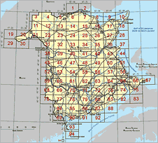
NB Atlas Map Index
 |
|
NB Atlas map of Edmundston (21N/08)
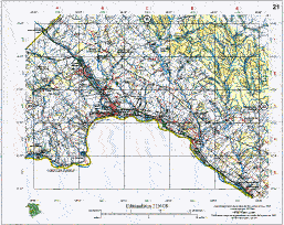 |
It provides a wealth of information, including: provincial highways, local and seasonal roads, ferry crossings, railroad and power lines, and airports. Prominent natural features such as lakes, rivers and mountains are shown, as are national parks, wildlife areas, camp and picnic grounds. Provincially owned lands are clearly marked, as are forestry cuts and silviculture on provincial lands. To view the map legend, click here.
The second edition, revised in 2002, of the New Brunswick Digital Atlas was derived from the following data sources:
- Features are derived from the Enhanced Topographic Base prepared by Service New Brunswick using aerial photography acquired from 1982 to 1991, except where noted below.
- Information about provincial highways is updated to September 1995, based on data provided by the New Brunswick Department of Transportation (NBDOT), with the following exceptions:
- Approaches to the Miscou Island Bridge were provided by NBDOT in 1997.
- Updates to the Confederation Bridge were provided by NBDOT in 1997 and 2002.
- Updates to the Trans-Canada Highway and some of its access routes were provided by NBDOT in 2002.
- Forestry roads are updated to 1993, based on data provided by the New Brunswick Department of Natural Resources and Energy.
- Municipal roads are updated to 1995, based on data from the Digital Property Map produced by Service New Brunswick.
- The Dobson Hiking Trail is portrayed using information provided by Fundy Hiking Trail Inc. The Fundy Foot Path is based on data provided by Fundy Model Forest.
- Airports (Canadian Flight Supplement) are airports listed in the Canadian Flight Supplement published 30 January 1997 by Natural Resources Canada.
- Airports (Condition Unknown) are derived from the Enhanced Topographic Base prepared by Service New Brunswick using aerial photography from 1982 to 1991. Airports (Condition Unknown) represent airports contained in the Enhanced Topographic Base that are not in the Canadian Flight Supplement published 30 January 1997. These airports may no longer be active.
- NB Power transmission lines are updated to 1996 using data provided by NB Power.
- NB Provincial Lands are updated to 1996, based on data provided by the New Brunswick Department of Natural Resources and Energy.
- Forestry Harvest Areas are updated to 1993 for provincial lands (private lands may not be as up-to-date), based on data provided by the New Brunswick Department of Natural Resources and Energy.
- Silviculture Treatment Areas are updated to 1993, based on data provided by the New Brunswick Department of Natural Resources and Energy.
- Magnetic declination and annual change for the centre of each Atlas digital map were calculated by the Nova Scotia Geomatics Centre using Magdec software (1996) distributed by Natural Resources Canada.
*Please Note: The NB Atlas maps are available in Portable Document Format (PDF). You need the Free Adobe® Reader® to view, save and/or print them.
|
|
|