|
|
Softcopy Orthophotomap Data Base (SODB) - Information
The Softcopy Orthophotomap Data Base (SODB) consists of geometrically corrected aerial photographs of New Brunswick, which are called orthophotos. They combine the image characteristics of aerial photographs with the geometric qualities of maps.
What is an orthophoto?
An orthophoto is a geometrically corrected aerial photograph. It is generated when the effects of tilt and terrain relief are removed from the aerial photograph by a process called orthophoto rectification, allowing for ground features to be displayed in their true ground position. This allows for the direct measurement of distances, areas, and positions (if printed at scale or used in a Geographic Information System). An orthophoto may serve as a base layer onto which other map information may be placed over. When two or more orthophotos are merged or mosaiced together then clipped to a specific area, an orthophotomap is created.
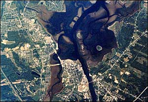
Example of an orthophotomap
(Downtown Bathurst) |
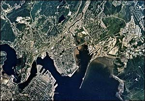
Example of an orthophotomap
(Downtown Saint John) |
|
|
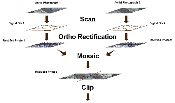
How is an orthophotomap made?
The process used to produce orthophotomaps can be divided in three sections (see Figure 1 for view of complete process):
- Aerial Photograph Collection
The first step in the orthophotomap production process is to collect the aerial photographs. Aerial photographs are taken vertically with a specialized camera installed on a specially equipped airplane. In order to assure a complete coverage of all areas and to produce �3-d� images, each part is photographed at least twice from two different positions at slightly different angles, and always at the same altitude. Special care is also taken to minimize shadows, which result from the Sun�s position, by taking the photographs in midday. It is also important to take the photographs on a clear day without any clouds, or other obstructions (e.g. smoke or haze).
The camera film is then developed and diapositives are produced for each photograph taken. The diapositives are scanned to create unrectified digital image files. From these image files, the process of orthophoto rectification can start.
- Orthophoto Rectification
When a vertical photograph is collected from the airplane, it represents a planar (2-d) reference of a curved (3-d) surface. The photograph also includes distortion due to the camera lens and the tilt of the airplane. To produce a rectified photograph (or orthophoto), the application of certain parameters like aeriotriangulation, digital terrain model and ground control points, is necessary. Note: A definition of these parameters can be found at the end of this document. These parameters will correct the distortion caused by airplane tilt, camera lens and the uneven surface of the Earth.
- Orthophotomap Production
Mosaicing two or more orthophotos and then clipping them to a certain area or grid produces an orthophotomap. During the mosaicing process, care is taken in assuring there is a colour balance between the orthophotos in order to produce a perfectly uniform orthophotomap; this process is called radiometric correction.
The final step is to clip the mosaiced orthophotos to a specific area. The SNB orthophotomaps available in the Geographic Data & Maps section were produced by using the NB 1:10,000 windows.
Figure 1 � Orthophotomap Production Process
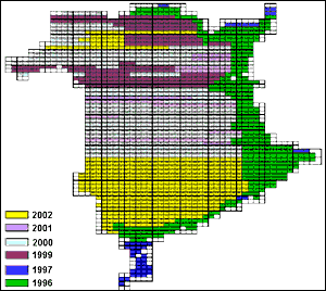
SODB Year of Photography |
 |
Spatial Framework
- Reference System: North-American Datum 1983 (CSRS)
- Projection: Stereographic Double
- Resolution (X,Y): 1.0 metre
- Nominal Scale: 1:10,000
- Accuracy: +/- 6.0 metres for well-defined features
File Naming Convention
The naming convention for the SODB files is based on the latitude and longitude (expressed in decimal degrees) of the Southeast corner of the 1:10,000 windows. These file names are coded as follows:
aaaabbbb, where
- aaaa is the North latitude of the Southeast window corner, expressed as a 4-digit integer number in decimal degrees to the nearest 0.01 degree.
- bbbb is the West longitude of the Southeast window corner, expressed as a 4-digit integer number in decimal degrees to the nearest 0.01 degree.
For example, the SODB file name for the window having its Southeast corner at latitude 46� 00� 00�� N (or 46.00) and longitude 66� 54� 00 E (or 66.90) is 46006690.
Available for Download�
The orthophotomaps are currently available for download as individual map windows (1:10,000) in these image formats: TIFF (4-metre resolution) and MrSid (1-metre resolution). However, they are not available for all regions of the Province (use the Upcoming Products and Services section for more details).
The original uncompressed 1-metre SODB files are not available for download in the Products & Services section; this is mainly due to their large size (approximately 130 MB each). In order to make these files easily accessible and free to the general public, SNB has resampled them to four (4) metres. Even though this resampling has reduced the quality of the files, they are easier to use and still very informative. The original uncompressed 1-metre SODB files are available, please use the Contact Information section to request more information. However, a lossy compressed version of each softcopy orthophotomap was generated to provide a smaller file size alternative while maintaining the overall quality of the original file.
Here are the downloadable SODB file packages:
- Compressed 1-metre MrSID (Multi-resolution Seamless Image Database)
The compressed 1-metre MrSID orthophotomaps are available as one (1) ZIP file for each 1:10,000 window currently available. The file size for the zipped compressed 1-metre MrSID orthophotomaps is between 2 MB and 3.5 MB.
Each ZIP file contains:
- Corner georeferencing coordinates in ASCII text format, with the *.cor file extension.
- CARIS GIS corner georeferencing coordinates, with the *.iga file extension.
- Compressed image in MrSID format, with the *.sid file extension.
- Surround map file, with the *.sur file extension.
- TIFF World file georeferencing information, with the *.tfw file extension.
- CARIS GIS vector transparency mask file, with the *.vtm file extension.
- Uncompressed 4-metre TIFF (Tagged Image File Format)
The uncompressed 4-metre TIFF orthophotomaps are available as one (1) TIFF file for each 1:10,000 window. The file size for the uncompressed 4-metre TIFF orthophotomaps is between 8 MB and 10 MB. The TFW (TIFF World) files are needed to georeference the TIFF files, they are available for download in the Products & Services section.
Please note: For more information on the Softcopy Orthophotomap Data Base (SODB), please use the Contact Information section on the Geographic Data & Maps � Main Page.
|
|
|